


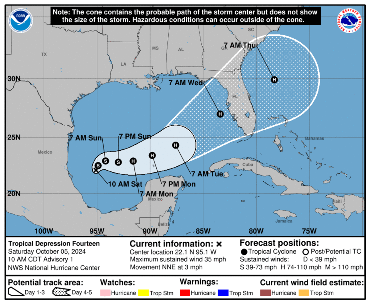
Tropical Storm Milton is rapidly intensifying and is projected to become a significant hurricane within days, threatening Florida’s west coast, particularly the Tampa Bay area. The National Hurricane Center has indicated that Milton, currently evolving from a tropical depression to a tropical storm, is expected to achieve hurricane status within 36 hours and major hurricane status — a Category 3 — within 72 hours. Governor Ron DeSantis has already declared a state of emergency in 35 counties, including Pinellas County, which is still recovering from the devastating impacts of Hurricane Helene. The governor’s declaration anticipates severe storm surge and wind effects that could commence as early as Tuesday evening and continue into Wednesday.
Milton’s emergence coincides with the aftermath of Hurricane Helene, which previously struck Florida’s Big Bend region and caused significant destruction and fatalities. Helene’s effects included severe flooding and high winds, claiming 12 lives in Pinellas County alone and contributing to a total of at least 230 fatalities across multiple states. With Milton’s explosive growth spurred by the unusually warm waters in the Gulf of Mexico—temperatures nearing 86 degrees—forecasters express concerns about another possible disaster for Florida and surrounding areas. The storm’s quick intensification also highlights its rarity, particularly as Milton is becoming the fifth hurricane to make landfall on the U.S. mainland in 2024, a record-setting pace reminiscent of historically active hurricane years.
Unusual storm characteristics further complicate expectations as Milton develops in the Bay of Campeche, a southern section of the Gulf of Mexico, which has historically produced very few storms impacting Florida. Only two hurricanes originating from this area have hit the state since records began in 1850. Milton is also notable for becoming the sixth named storm of this Atlantic hurricane season, which has already witnessed an unusually high number of storms between late September and early October. Forecasts indicated that heavy rainfall would begin impacting Florida as early as Sunday, escalated by Milton’s approach.
As of the latest updates, Milton shows maximum sustained winds of around 45 mph and is moving north-northeast. Although a tropical storm watch is in effect for parts of the Yucatan Peninsula, hurricane and storm surge watches are anticipated for Florida’s coast. The hurricane center warns that heavy rainfall is likely across much of the state, with projections suggesting up to 8 inches of rain in some areas, raising concerns for flash flooding and moderate river flooding.
Officials are urging residents to prepare for the incoming storm by reviewing their emergency plans and staying informed about the potential risks. In direct response to the impending threat, local authorities in Pinellas County are making sandbags available to residents. Furthermore, the hurricane center emphasizes the importance of having supplies such as food, water, fuel, and medications at hand, as well as cash reserves in case electronic payment systems fail. As the storm continues to develop, residents are advised to act quickly to ensure their safety and preparedness ahead of Milton’s potential impacts.
With the storm still a few days away, uncertainties about its exact path and intensity remain, which is typical for hurricane forecasting. The National Hurricane Center continues to monitor the situation closely, providing updates as needed. Overall, Milton’s rapid development highlights the importance of readiness and vigilance among communities along Florida’s west coast as they brace for potentially dangerous impacts from the storm.


