


As autumn grips the nation, attention turns towards the impending winter, which could differ significantly from the previous year’s El Niño-dominated season. Forecasts indicate a weak La Niña event is likely to develop, affecting temperatures, precipitation patterns, and snowfall across the United States. La Niña is characterized by cooler than average ocean temperatures in the equatorial Pacific and has notable impacts on weather, especially during the winter months in the Northern Hemisphere. Last winter set records for warmth across the contiguous United States, drawing a stark contrast to typical winter weather, as it was largely shaped by the influence of El Niño, coupled with an overall warming trend driven by climate change.
Meteorologists from the Climate Prediction Center anticipate a 60% likelihood of La Niña’s emergence prior to the winter season, with expectations that it will potentially last into early spring. Despite La Niña or El Niño being critical factors in seasonal weather, various other phenomena also play roles. The intensity of La Niña varies, and its strength significantly influences its weather impacts. Stronger events tend to produce more predictable weather patterns, while weaker La Niña occurrences are often disrupted by other climatic influences, diminishing their consistency. Monitoring updates from the Climate Prediction Center will be crucial, as the agency’s predictions can fluctuate based on new data.
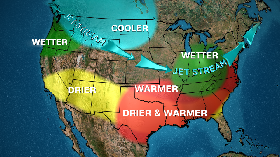
Regular patterns observed in La Niña winters provide insight into what to expect. The behavior of the jet stream, which strongly influences storm tracks, typically shifts northward during La Niña years, redistributing stormy weather predominantly into the northern United States. Current reports predict that much of the northern regions, especially the Pacific Northwest and the Midwest, will experience wetter conditions, addressing existing drought issues, a prominent shift from the previous winter’s drier north and wetter south dynamic.
However, increased precipitation does not guarantee enhanced snowfall, as surface temperatures also play a vital role. Historical data suggests that weak La Niña events often correlate with additional snowfall in the Northeast, whereas stronger events typically lead to warmer conditions and less snow accumulation on the East Coast. This year’s forecasts lean towards warmer than usual conditions across much of the southern United States and parts of the Eastern states. For winter enthusiasts in the Northeast, the outlook poses challenges as predictions indicate a higher likelihood of rain rather than snow, illustrating the potential complexities of this winter season.
In conjunction with precipitation expectations, regions of the Midwest, Plains, and Rockies are projected to witness near-normal temperatures. Meanwhile, the Pacific Northwest may experience cooler conditions, potentially resulting in beneficial snow acquisition critical for water supply and tourism. While Northern California could see precipitation close to normal levels, Southern California is expected to have drier and warmer weather, both classic indicators of La Niña conditions. This raises significant concerns regarding wildfire season, emphasizing the need for substantial soaking rains to mitigate fire risks, as ample vegetative fuel exists from the prior summer months.
As stakeholders across various sectors prepare for winter, the interplay of temperature, precipitation, and prevailing climate patterns becomes essential for forecasting seasonal impacts. By understanding the implications of La Niña, meteorologists, policymakers, and communities can better prepare for the winter months ahead. Whether addressing agricultural needs, managing water resources, or planning for winter weather-related events, these forecasts underscore the importance of adaptive strategies in response to evolving climate phenomena. Through continued monitoring and research, practitioners hope to refine their predictions, enabling societies to better brace for the upcoming challenges inherent to the winter season.


