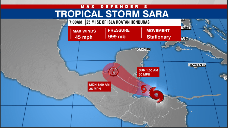
Tropical Storm Sara is currently positioned near Central America, exhibiting minimal movement while persistently releasing heavy rainfall in the region. As per the National Hurricane Center’s update on Saturday morning, the storm maintains maximum sustained winds of 45 mph. Anticipated to commence a west-northwestward journey, Sara is expected to gain some speed as it advances into Sunday. The projected path of the storm suggests that it will glide over the northern coastline of Honduras this weekend before making landfall in Belize by midday Sunday. Central America is bracing itself for severe weather conditions, with Honduras potentially receiving rainfall amounts ranging from 15 to 25 inches.
In terms of warnings issued by the weather authorities, a tropical storm warning is operational for various regions, which includes the northern coastal areas of Honduras stretching from Punta Patuca to the Honduras-Guatemala border, the Bay Islands of Honduras, the Caribbean Sea coastline of Guatemala, and the southeastern coastal stretches of Mexico, from Puerto Costa Maya to Chetumal. The warnings reflect the need for residents and officials in these areas to remain vigilant and prepared for the potential impacts of the storm, especially regarding flooding and strong winds.
Forecasters indicate that while Tropical Storm Sara may experience slight strengthening over the weekend, it is anticipated to lose its tropical storm status by Sunday night or Monday as it moves across Mexico’s Yucatan Peninsula. As it interacts with the landmass, dynamics of the storm’s structure are expected to shift, leading to its eventual dissipation. Meteorologist Eric Stone from Max Defender 8 notes that the remnants of the storm are likely to move into the Gulf of Mexico, where they are not expected to re-develop into a significant weather system.
As the remnants of Sara progress toward the Gulf, they may be accompanied by rain and moderate winds, which could also interact with an incoming cold front expected to pass through the Bay Area on Wednesday. The weather situation is being closely monitored, and residents are advised to track updates in real-time as conditions evolve. The potential for localized flooding and hazardous weather is an ongoing concern as communities prepare to respond to the residual effects of the storm.
In light of the approaching storm and the broader hurricane season, residents are encouraged to arm themselves with preparedness resources. The 2024 Hurricane Guide provides valuable insights and safety measures that can be vital during such tropical events. Moreover, subscribing to the Tracking the Tropics newsletter can help individuals stay updated with real-time information and develop a better understanding of any tropical systems that may threaten their area.
To summarize, Tropical Storm Sara remains nearly stationary, expected to impact Central America significantly before moving toward the Yucatan Peninsula. The rainfall forecast for Honduras poses a considerable risk, prompting tropical storm warnings across multiple regions. As the storm transitions and weakens, it is vital for inhabitants of the affected areas to remain vigilant and stay informed, utilizing available resources to ensure their safety and preparedness. The situation highlights the ongoing importance of monitoring tropical developments and adhering to safety measures during hurricane season.

