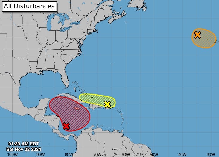
A tropical depression, potentially evolving into a tropical storm, is developing in the southwestern Caribbean Sea, designated as Invest 97L by the National Hurricane Center. According to their 2 p.m. Tropical Weather Outlook, the Air Force Hurricane Hunter Aircraft is set to investigate this system further. Forecasters have indicated a 70% probability of development over the next two days, as it progresses northward towards Central America. There is another weather system eastward near Puerto Rico that may bring thunderstorms to the Greater Antilles before merging with a larger disturbance. Additionally, a named storm, Subtropical Storm Patty, formed off the western Azores, which in itself poses no immediate threat to Florida.
Ryan Truchalat, a forecaster and owner of Weathertiger, explained that the current weather patterns suggest that potential storms could either drift west or northwest into the southwestern Gulf of Mexico. Other modeling scenarios could see the storm changing directions towards Florida if a front passes through more quickly and vigorously. Although Florida is currently clear of immediate hurricane threats, vigilance is still advised as conditions can change rapidly. The names expected for upcoming storms are Rafael and Sara, as the hurricane season typically brings about significant weather changes during November.
As of 5 p.m. on November 2, Subtropical Storm Patty was located roughly 170 miles west-northwest of the Azores, with maximum sustained winds of 65 mph and moving at 18 mph east-southeast. Forecasters anticipate some weakening, expecting Patty to possibly transform into a post-tropical cyclone by late Sunday. The storm’s influence on land includes the possibility of tropical storm conditions and rainfall between 1 to 2 inches across the Azores, along with hazardous surf and rip current conditions resulting from the generated swells.
November is often a month of concern for hurricane development in Florida, given that since 1851 there have been only three hurricanes striking the state during this time. Unlike earlier months in hurricane season, which typically see storms forming far out in the Atlantic, late-season development shifts focus closer to the USA. As Hurricane forecaster DaSilva notes, the Caribbean and Southeast coast become the primary regions for potential storms as November progresses, making Invest 97L a system to monitor closely.
The weather system classified as Invest 97L consists of disorganized showers and thunderstorms, indicative of a broad area of low pressure. Meteorologists expect these conditions to gradually develop into a tropical depression moving northwards or northwestwards across the central and western Caribbean, leading to heavy rainfall over Jamaica, Hispaniola, and Cuba. With an 80% chance of formation in the coming week, this system could create significant impacts in adjacent regions, necessitating prepared responses from local residents and authorities.
Conversely, a system off the Greater Antilles is exhibiting minimal chances for development, currently sitting at only 10% over the next week. However, it could still produce heavy rains and potentially affect parts of Puerto Rico and the Bahamas. The warm waters of the Caribbean provide a conducive environment for tropical development paired with low wind shear, creating a significant risk for disturbances in this time frame. Tropical weather updates will continue to be provided as conditions evolve, and residents are encouraged to remain attentive to updates to stay informed on potential impacts from either Invest 97L or ongoing systems in the Atlantic.

