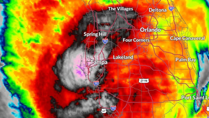
Hurricane Milton has made landfall on October 10, 2024, hitting near Siesta Key, Florida, as a Category 3 storm with winds of 120 mph. The National Hurricane Center confirmed that the storm was moving at 14 mph and had been assessed as one of the most intense hurricanes, with maximum sustained winds previously exceeding 160 mph. Before its landfall, there were significant weather warnings for the entire Gulf Coast, with Special Weather Alerts advising residents to seek shelter as the northern eyewall approached. A concerning phenomenon revealed that water had been significantly sucked out of Tampa Bay, which is often indicative of an approaching storm surge.
By early Wednesday evening, as anticipation built for Hurricane Milton’s landfall, weather advisories indicated that the storm could transition to a Category 5 hurricane, pushing record storm surge projections of up to 15 feet in some areas. The storm’s trajectory involved a hard right turn that was expected to land it somewhere between Bradenton and Sarasota, alleviating some immediate storm surge threats for Tampa Bay while exacerbating risks for southern communities, including Sarasota, Siesta Key, and Venice. With warnings for catastrophic flash flooding and high storm surges, residents were cautioned to heed evacuation orders.
Reports indicated disruption across Florida’s Gulf Coast, with over half a million electric customers losing power due to fierce winds and tornado warnings that had been issued across South Florida. Multiple tornadoes had been confirmed by various National Weather Service stations, reflecting the storm’s severe impact. Emergency services reported extensive power outages and rising fears of flash flooding. In heavily affected areas like Sarasota, evidence of power flashes and strong winds indicated worsening conditions, with visuals capturing debris being swept down flooded streets.
By Tuesday night, the situation escalated as the storm strengthened, prompting massive evacuations—the most pivotal since 2017. Mandatory evacuation orders were issued across numerous counties along Florida’s Gulf Coast, affecting areas like Hillsborough, Lee, Charlotte, and Sarasota Counties. The Florida Division of Emergency Management urged residents to evacuate to ensure their safety, with Tampa’s mayor stating that remaining in certain areas could lead to fatal consequences. Traffic on highways leading away from affected zones illustrated the urgency of the situation as the storm barreled closer.
Despite the evacuation orders, local authorities expressed concern for residents who chose to remain, warning that they would be “on their own” in the face of the impending disaster. The sheriff’s department reinforced the gravity of the situation through stern advisories about emergency response limitations. Reports of massive traffic jams leading north on I-75 underscored the exodus from hurricane-threatened areas as residents attempted to escape the imminent danger posed by Hurricane Milton.
As Hurricane Milton’s landfall unfolded and initial impacts were felt, the overall response indicated preparedness for one of the most severe storm systems recorded in recent history. Additional safety alerts were disseminated, emphasizing the significance of storm surge and high winds. The pattern of devastation portrayed by consistent power outages, tornado sightings, and flooding demands a comprehensive evaluation of emergency protocols and storm preparedness in a region frequently battered by hurricanes, learning from previous storms to cope effectively with the threats posed by future hurricanes. The intensity and rapid onset of Hurricane Milton exemplified the critical need for efficient communication and preparation in the face of such climate-related threats.

