


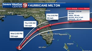
Meteorologists at Severe Weather Center 9 are closely monitoring Hurricane Milton, which is currently intensifying as it approaches Florida. The storm is classified as a powerful Category 5 hurricane with sustained winds reaching up to 165 mph, as reported in the latest advisories from the National Hurricane Center. The focus of attention is on the storm’s intensity, with forecasts suggesting that it will make landfall near Anna Maria Island or Sarasota in the early hours of Thursday. The potential for widespread destruction is significant, with authorities warning about extreme conditions, including heavy storm surge and hurricane-force winds impacting Central Florida.
As Hurricane Milton progresses, its path has adjusted slightly to the north, and forecasts now indicate it may weaken to a Category 4 hurricane upon landfall but will still pose a serious threat to the region. In anticipation of the storm, Hurricane Warnings have been issued for much of Central Florida. Meteorologists project that as Milton crosses Central Florida on Thursday morning, it could still be a potent Category 2 hurricane, bringing with it gusts of winds between 90 to 100 mph, extensive tree damage, and debris that poses risks to vehicles and property.
The Florida Governor, Ron DeSantis, has planned a press conference to address the state’s preparations for Hurricane Milton. Various state officials from emergency management, transportation, and law enforcement will join him to provide the latest updates. The collaboration among these departments highlights the urgency and seriousness with which officials are treating this potential disaster, as they communicate strategies for public safety and the logistics of emergency response.
Current modeling forecasts suggest a likely landfall in Manatee County around 1 a.m. on Thursday, with impacts expected to begin well before that time. The storm’s trajectory indicates that it will affect not only the West Coast but also areas across Central Florida, leading to dangerous conditions such as flooding rains anticipated to be between 8 to 14 inches, as well as possible tornadoes. Precautions, including mandatory evacuations for certain regions, have been implemented to ensure the safety of residents.
Meteorologist Brian Shields emphasized the necessity of vigilance regarding the storm’s intensity throughout Wednesday, as conditions could deteriorate swiftly. Residents are urged to finalize their hurricane preparedness plans by noon on the day the storm is expected to hit. As Hurricane Milton nears Florida, officials advise communities to remain updated and heed warnings, emphasizing that this hurricane could be among the most significant weather events in recent history for the region.
In conclusion, the anticipated worst impacts of Hurricane Milton, including significant storm surges and powerful winds, are expected to coincide with high tide on Thursday afternoon. This time frame increases the risk of catastrophic flooding in vulnerable coastal areas. The Severe Weather team has committed to providing continuous live updates on Hurricane Milton, ensuring that the public stays informed throughout the storm’s progression and understands the safety measures required during this precarious situation.


