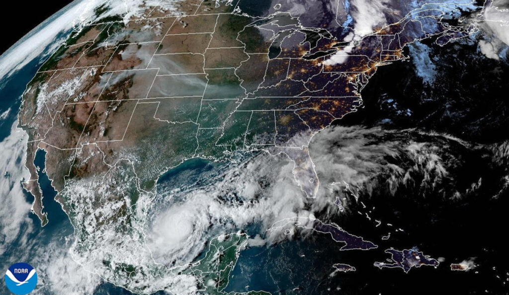
Hurricane Milton has rapidly intensified into a powerful storm, drawing energy from the warm waters of the Gulf of Mexico. The National Hurricane Center (NHC) initially warned that Milton could become a major hurricane, which is classified by sustained winds of at least 111 mph. By 8 a.m. on Monday, their predictions were validated as the storm escalated to a “potentially catastrophic” Category 5 hurricane. By early Tuesday, Milton was recorded as a Category 4, boasting winds of 155 mph, but it quickly regained its status as a Category 5 hurricane by Tuesday afternoon, with winds reaching 165 mph. The storm was located approximately 475 miles southwest of Tampa, Florida, which was preparing for the possibility of a direct impact.
Forecasters from NBC News provided updates indicating that while Hurricane Milton exhibited incredible strength, it was possible for the storm to weaken back to a Category 3 hurricane before making landfall. The expected timeline for landfall was set for Wednesday night on Florida’s west coast, adding urgency to preparations for affected residents and officials. By Tuesday night, heavy rain, fierce winds, and the threat of storm surges were anticipated to impact the region, with the arrival of hazardous weather conditions due to Milton’s approach. As forecasts continued to evolve, it remained essential for coastal residents to remain vigilant.
As Milton drew closer, federal forecasters cautioned that life-threatening storm surges would affect nearly the entire west coast of Florida. The storm was predicted to bring torrential rainfall, leading to flash floods and destructive winds concentrated near its center, initially estimated at 111 mph or more. The impact area of hurricane-force gusts was expected to extend approximately 30 miles out from the eye of the storm, with that radius potentially doubling before landfall. Weather experts indicated that by Wednesday night, tornado activity might be possible across areas in the Florida Peninsula as the storm progressed eastward, making its way into the Atlantic Ocean by Thursday.
The forecasted potential impacts were extensive, with significant coastal and inland cities—including Tampa, Orlando, Daytona Beach, Sarasota, Fort Myers, and Naples—at risk of severe consequences such as power outages from wind damage, flooding from both storm surges and heavy rains. Authorities predicted rainfall accumulations reaching up to 8 inches and storm surges of up to 15 feet in coastal communities, underscoring the seriousness of the impending weather event. Emergency preparedness was vital for residents in these areas as they braced for the possibility of Milton’s landfall.
Milton’s rapid intensification was particularly noteworthy, especially as the region was still recovering from the devastation caused by Hurricane Helene. Helene made landfall in Florida’s Big Bend region on September 26, leading to over 230 fatalities across six states, which illustrated the grave danger posed by hurricanes in the Southeast. Milton’s formation was unusually significant as it originated from the southwestern Gulf of Mexico, an atypical path compared to most hurricanes that typically arise in the Caribbean or Atlantic. The storm originally developed as Tropical Depression 14 in the Bay of Campeche and then made its way across the Gulf, marking a historically rare trajectory not documented since 1867.
As Hurricane Milton continued its threatening approach toward Florida, residents and officials effectively prepared for its anticipated impacts, drawing on recent experiences from past hurricanes. Continuous updates from the NHC and weather agencies provided guidance on safety measures and evacuations when necessary. The convergence of warm water temperatures and meteorological conditions contributed to Milton’s explosive growth in intensity, creating a scenario that necessitated substantial awareness and action in vulnerable areas. The evolving situation illustrated both the ferocity of nature and the importance of heeding expert forecasts, raising questions about climate patterns and future hurricane preparedness in the region.

