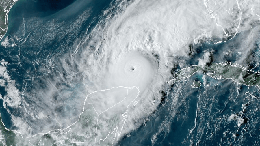
As hurricane season brings heightened activity to the Gulf of Mexico, with Hurricane Milton currently forming and various Southeast cities recovering from the impacts of Hurricane Helene, meteorologists have been using several technical terms related to hurricane behavior. These terms can often be confusing for the general public. Understanding basic hurricane terminology is essential in making sense of weather reports and predicting potential impacts. Key components of a hurricane include its structure, classifications, and meteorological factors that can influence its behavior and intensity.
A hurricane is typically characterized by three main parts: the eye, the eyewall, and the outer rainbands. The eye is the calm, central region of the storm that appears as a clear “hole,” where winds are generally light and weather conditions may seem favorable. Interestingly, a smaller eye can signify a stronger storm, as it enables the hurricane to spin more rapidly, leading to stronger wind speeds. Surrounding the eye is the eyewall, which contains the most severe weather and strongest winds, facilitating the storm’s intensification. The outer rainbands, meanwhile, are spiraling rain and storm areas farther from the center that can contribute to heavy rain and localized tornadoes, demonstrating that the impacts of a hurricane extend significantly beyond its eye.
Hurricane strength and intensity are quantified using terms such as maximum sustained wind and wind gusts. Maximum sustained wind refers to the highest consistent wind speed measured over a duration of at least 20 seconds, typically assessed at a height of 33 feet above the ocean surface. This metric is vital in categorizing hurricanes on the Saffir-Simpson Scale, which ranges from Category 1 (74-95 mph winds) to Category 5 (157 mph or more). Wind gusts, in contrast, are brief spikes in wind speed, usually 10 mph stronger than the sustained winds for 20 seconds or less. Understanding these terms allows individuals to better gauge the potential severity of hurricane conditions.
One of the critical forecasting tools for hurricanes is the “cone of uncertainty,” which illustrates the predicted path of a hurricane’s center based on available meteorological data. This forecast shows the likely track at intervals that extend out to five days prior to potential landfall, indicating the center’s trajectory without providing specifics on the storm’s overall size or the extent of its effects. A tighter cone reflects greater confidence in the forecast, while a wider cone suggests uncertainty. This forecast is typically updated every six hours and is essential for emergency preparedness and response actions for coastal communities.
Hurricanes thrive in warm ocean water, with sea surface temperatures above 80 degrees Fahrenheit being optimal for development. Such temperatures provide the heat and moisture necessary for a hurricane to strengthen. Conversely, the phenomenon of wind shear—variations in wind speed and direction over short distances—can hinder a hurricane’s development. Strong wind shear can disrupt a storm’s structure and energy transfer, often leading to weakening or disintegration. Together, sea surface temperatures and wind shear play pivotal roles in determining the overall life cycle and intensity of a hurricane.
Meteorological events during hurricane season may also include phenomena like storm surge and rapid intensification. Storm surge, driven by hurricane winds pushing water towards shorelines, results in higher water levels and can inundate areas far inland, posing significant flood risks. Rapid intensification occurs when a hurricane’s maximum sustained winds increase by at least 35 mph within a 24-hour period—a striking transformation that can elevate a storm from a lower to a higher category on the Saffir-Simpson Scale. Such instances, like the recent rapid intensification of Hurricane Milton, highlight the unpredictable nature of hurricanes and the range of conditions that can lead to sudden changes in intensity.
Finally, meteorologists monitor the eyewall replacement cycle, a complex process that can affect hurricane strength. In strong storms, outer rainbands may form an additional ring of thunderstorms, occasionally leading to the collapse of the original eyewall as the system rearranges itself. This cycle of weakening and eventual re-strengthening is critical in understanding how hurricanes evolve and can affect forecasting efforts. Recognizing these patterns equips both meteorologists and the public with a clearer understanding of hurricane behavior, essential for effective preparedness and response strategies as the season progresses.

